Europe models · Option 1
Six real geographic GLBs, generated for the Europe Option 1 / A budget. Open a cell to rotate, inspect and download it. These are coarse cartographic terrain prototypes, not synthetic export probes or flight-ready scenery.
The user authorized generation and documentation publication of these six Europe assets. This is not human design/UAT approval, an approved continent boundary, a performance certification or application integration. Other continents remain planning-only; existing models are unchanged.
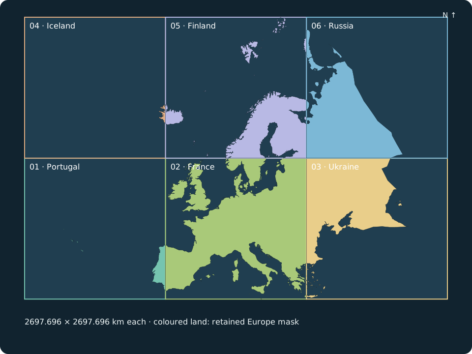
Choose a model
| Cell | Individual interactive preview | General footprint |
|---|---|---|
| 01 | Portugal | Southwest square; includes part of Portugal |
| 02 | France | South-central square; includes France |
| 03 | Ukraine | Southeast square; includes part of Ukraine |
| 04 | Iceland | Northwest square; includes part of Iceland |
| 05 | Finland | North-central square; includes Finland |
| 06 | Russia | Northeast square; includes European Russia and grey non-Europe context |
Names identify actual, possibly partial countries inside the squares, not country borders, whole-country models or six political regions. Every square is 2697.696 × 2697.696 km in EPSG:3035.
Geography and partition contract
The mask follows a coarse, explicitly digitized interpretation of the Urals → Ural River → Caspian Sea → Greater Caucasus → Turkish Straits convention. It does not reuse the historical Natural Earth CONTINENT=Europe inventory that put all Russia in Europe. Asian Russia is excluded. The National Geographic physical-geography account places Europe between Iceland and the Urals and includes the Caucasus; the Russian Geographical Society's boundary investigation explains the Ural Mountain / Ural River convention and disputed interpretations.
This implementation's eastern polyline is an author-digitized continental-scale approximation, retained in research/europe-option1/boundary.json, not a surveyed ridge/river centreline or a claim that one universal Europe boundary exists. A future accepted boundary can change the mask and assets. It includes source-represented Iceland, British Isles, Svalbard, western Russian Arctic islands and European portions of transcontinental states. Greenland, Asian Russia, Cyprus, Canaries, Madeira and overseas territory south of 34°N are excluded. Greek islands follow their source country polygons. Coastlines are generalized 1:50 million; inland water is removed only where the source polygons contain holes.
The exact old intended-Europe mask is retained, including its islands and author-digitized divide. Exactly six aligned squares in a 3 × 2 grid, south row first, cover it without positive-area gaps or overlaps; shared complete edges have zero area. Land areas are not equal. Full squares extend beyond the mask into flat marine water and non-Europe context. Grey land is outside intended Europe and may include Asian Russia; it does not expand the Europe mask. The measured mask totals approximately 10.099 million km²; the 10 million km² planning input remains rounded. Exact projected footprints are in cells-projected.json; cells.geojson is historical, not the current partition. Actual measurements are in the manifest.
Real elevation source and actual detail
- Terrain: SRTM15+ v2.7, Tozer et al. (2019), distributed by the GMT Earth Relief service. Pinned JP2 tiles have 1 arc-minute gridline source spacing; their retained acquisition metadata describes a 5.2 km full-width Gaussian filter, replacing the old 10 arc-minute / 52.4 km derivative. The live GMT table now describes 1.9 km for 01m; that metadata discrepancy does not establish a change to these hashed inputs. Arc minutes are angular spacing, not metres; longitudinal ground spacing varies with latitude. The underlying source is not a common acquisition date.
- Elevation handling: decode GMT integer samples with the 0.5 m scale factor and bilinear-sample real heights across every full square. Only verified marine interior vertices become a flat nominal 0 m sea surface. The Atlantic-connected polygon in pinned Natural Earth ocean data supplies the marine classification; the separate Caspian polygon, all pinned country land and lake polygons are excluded. Non-marine vertices—including below-sea-level land and uncertain inland lake/bathymetry—remain bit-for-bit unchanged. Inland lake surface reconciliation is unresolved and outside this iteration. This is not a universal negative-height clamp or a current tidal-level model. Coastlines remain source-generalized; mixed land/water triangles interpolate at the unchanged mesh spacing, not a shoreline-conforming water mesh.
- Geometry: each full square has a 273 × 273 mesh, 9,918 m mesh spacing, 74,529 vertices and 147,968 triangles. Mesh spacing is distinct from source spacing and texture resolution; none undo upstream filtering. This bounded ocean-only stage preserves topology and land relief: zero triangles saved, no adaptive land refinement claimed. Texture savings are measured rather than spent on invented detail.
- Horizontal coordinates: projected ETRS89 / LAEA Europe (EPSG:3035) metres, rebased around each cell's local easting/northing centre. X is east; Y is elevation; Z is negative northing. The global-to-local origins are explicit. This is a projected cartographic overview, not Earth curvature, ECEF or a flight ENU frame. WGS84 source coordinates are transformed by PROJ; no epoch-specific sub-metre accuracy is claimed.
- Vertical coordinates: source elevations in metres, without conversion to ellipsoidal height; the source vertical reference is inherited. Downloaded geometry is 1×. The viewer starts at 20× relief, labelled with a true-height switch so continental relief remains visible.
- Appearance: one embedded 2048 × 2048 texture combines hypsometry, hillshade and Natural Earth 1:50 million coast outlines. Verified marine pixels have a constant blue without depth gradients or seabed hillshade; unresolved inland appearance is retained. Grey land denotes non-Europe context. This is not satellite imagery, land cover or vegetation. Each self-contained GLB, including its image, is ≤5,000,000 bytes (5 decimal MB). No roads, buildings, airports, collision, water simulation, streaming, LOD transitions, navigation or flight physics.
Provenance, rights and reproduction
Credit: Tozer et al. (2019), SRTM15+ v2.7 via GMT; the authors' data record declares CC BY 4.0. The derivative terrain remains attributed under CC BY 4.0. Changes: upstream Gaussian filtering, bilinear sampling, square-grid triangulation, cartographic reprojection, local rebasing, baked hypsometry/hillshade and marine-only flattening. No endorsement is implied.
Boundaries: Natural Earth v5.1.2 ne_50m_admin_0_countries.geojson, pinned release source, public domain. Pinned ne_50m_ocean.geojson and ne_50m_lakes.geojson from the same v5.1.2 release supply marine connectivity and conservative inland exclusions, with exact hashes in ocean-source-lock.json. Administrative records supply generalized land/coast outlines only; selecting or clipping them does not assert sovereignty.
The repository retains downloaded inputs, SHA-256 locks, the explicit boundary, exact mask and six projected cells, pinned Python dependencies, generator, generated GLBs and manifest. The GLBs are direct source-derived review exports, not a separate optimized flight runtime variant. No runtime acceptance is implied.
python -m venv .venv-europe
.venv-europe/bin/pip install -r research/europe-option1/requirements.txt
.venv-europe/bin/python scripts/generate-europe-option1.py
.venv-europe/bin/python scripts/generate-europe-option1-pages.py
.venv-europe/bin/python scripts/validate-europe-option1.py
Generation is offline and bounded to six outputs. The manifest records actual bytes and elapsed generation time, not a performance estimate. Download/install, Python startup/imports, separate validation, upload and human review are excluded.
Recorded generation: 47.814 seconds. Total GLB bytes: 28,982,660.
| Square | Width × depth (km) | Decimal MB | Triangles | Generation (s) |
|---|---|---|---|---|
| Portugal | 2697.696 × 2697.696 | 4.327772 | 147,968 | 6.514 |
| France | 2697.696 × 2697.696 | 4.852392 | 147,968 | 7.112 |
| Ukraine | 2697.696 × 2697.696 | 4.970136 | 147,968 | 7.953 |
| Iceland | 2697.696 × 2697.696 | 4.992612 | 147,968 | 7.473 |
| Finland | 2697.696 × 2697.696 | 4.908728 | 147,968 | 6.865 |
| Russia | 2697.696 × 2697.696 | 4.931020 | 147,968 | 9.387 |
The square mesh uses a shared sample lattice at complete aligned edges. Cartographic adjacency is not flight-seam acceptance or evidence of globe curvature, collision or runtime precision.
Review boundary
Format validation, mesh/coverage assertions and browser preview checks are engineering evidence, not accepted visual quality or flyability. Cross-cell renderer precision, collision, high-detail DEM accuracy, licensing for future imagery, globe-to-flight handoff, hardware budgets and actual in-flight seams remain unimplemented or unvalidated. The globe remains continent selection only. No flight application is modified.